The Dempster (Highway 5) and Top of the World (Highway 9)
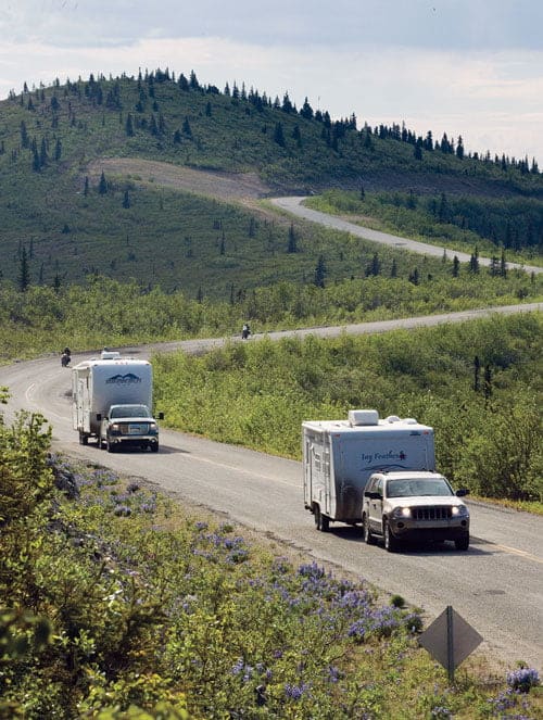
The Top of the World Highway is neither on top of the world nor is it a highway, but is certainly one of the most memorable drives in both Alaska and the Yukon. Technically, it runs 127 kilometres from Jack Wade Junction in Alaska, which is the end of the Taylor Highway, to the ferry landing in West Dawson and has been in existence since 1955 – but that’s the Chamber of Commerce version.
The Magnificent 11 The Yukon’s Highways
Hwy 1 – Alaska Highway
Hwy 2 – Klondike Highway
Hwy 3 – Haines Road
Hwy 4 – Robert Campbell Highway
Hwy 5 – Dempster Highway
Hwy 6 – Canol Road
Hwy 7 – Atlin Road
Hwy 8 – Tagish Road
Hwy 9 – Top of the World Highway
Hwy 10 – Nahanni Range Road
Hwy 11 – Silver Trail Highway
A map to this series
Part 1: Introduction and Canol Road (Hwy 6)
Part 2: Klondike Highway (Hwy 2) and Silver Trail (Hwy 11)
Part 3: Campbell Highway (Hwy 4) and Nahanni Range (Hwy 10)
Part 4: Atlin Road (Hwy 7) and Tagish Road (Hwy 8)
Part 5: The Dempster (Hwy 5) and Top of the World (Hwy 9)
Part 6: Haines Road (Hwy 3) and Alaska Highway (Hwy 1)
It’s been well known since the days of the Volstead Act (Prohibition) in the early 1920s that, with only minor detours, the route was used for bootlegging by dog mushers when Alaska was dry and Canada was wet.
A book titled Tisha: the Story of a Young Teacher in the Alaska Wilderness, as told to Robert Specht by Anne Hobbs, tells the memoir of a young woman who left her home in Colorado to become a teacher in Chicken, Alaska in the 1920s. The book documents the hilarious rivalry between competing bootleggers. And they had plenty of customers; there was considerable mining activity on both sides of the border with good pay streaks in both countries on the same creeks like Fortymile, which predates the Klondike as a mining destination by about 10 years.
Some of the biggest nuggets in Alaska history came off Jack Wade Creek.
The stretch of Top of the World Highway to Tetlin Junction, near Tok on the Alaska Highway, is summer-only, but the Yukon side was year-round when the Clinton Creek asbestos mine was running. The road is wide and good to that turnoff, but gets a tad bushy up in the border tundra and can be quite scary for Cheechakos (rookies) from the urbs.
The secret to driving it safely is going slow. Real slow. The Little Gold border crossing closes every night at 9 p.m. for 12 hours, so it’s one of the quietest and most beautiful spots in the Yukon to camp when all the traffic hunkers down for the night.
Chicken, so named because the old time miners who discovered it couldn’t agree on how to spell Ptarmigan, can be described in one word: Funky. It’s such an unusual drive visitors either want to get it over with quickly or stay for several days to soak it all up.

The Top of the World Highway is short, but rivals the Dempster for dramatic scenery while it lasts. Speaking of which, if you think of the Yukon’s Magnificent 11 highways as members of the same family, the Dempster is the rogue son who went off on his own at a young age to break the family tradition. It’s the only one in the family built to service the oil and gas industry, rather than war or mining, and specifically a proposed natural gas pipeline from the Mackenzie Delta to the Alaska Highway via the Klondike Highway then onto worldwide markets. It was a pipeline that was just a political pipe dream.
However, the Dempster did assist quite a bit of Arctic development over the decades since and is now a popular tourist road certain to soon get more popular since you can now drive it right to the shore of the Arctic Ocean at Tuktoyaktuk in the summer.Your humble, retired roadologist worked on the construction of the Dempster in the mid 1970s at Eagle Plains (driving dump trucks and running bulldozers). I know the road well, yet still feel awestruck every recreational trip I take up it as an old man. Two spots stand out as favourites:
- The view of the velvet mountains to the east from the POV of the Arctic Circle marker, and
- The big pullout up on the high Eagle Plateau just north of the Ogilvie River, with an amazing viewing platform facing due east. On your right (south) side are the Ogilvie Mountains, which were ravaged by the glaciers of the last Ice Age. On your left (north), are the smooth, soft looking mountains of the same range, which were never touched by any glaciers.
In between is the exact place where the Ice Age glaciers melted and retreated; the end of the trail for the glaciers if you will. It is startling to see the difference between glaciated and untouched mountains in the same range. That’s just one “must see” places on the Dempster and there are hundreds more that keep changing as you move north and the mountains keep getting smaller until they dive into the flat Arctic tundra like the tail of a sea serpent disappearing beneath the water. There are two ways for people in vehicles to reach pure alpine tundra in the Yukon. The first is to drive up a mountain until you get higher than the treeline and the second is to keep driving north on the continent until you leave trees and mountains behind and find yourself in the land of pingoes and whale blubber. You can do the first on the Top of the World Highway and the second on the (incomparable) Dempster, the crown jewels of the Yukon’s Magnificent 11 numbered highways.

